


UTNC

SityTrail - itinéraires balisés pédestres
Tous les sentiers balisés d’Europe GUIDE+
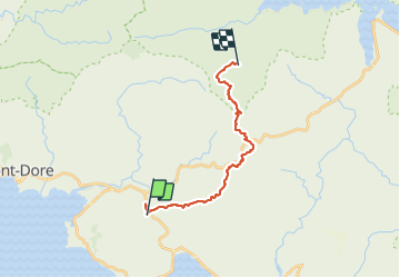

Length
22 km

Max alt
605 m

Uphill gradient
1351 m
Km-Effort
40 km

Min alt
55 m

Downhill gradient
1352 m
Boucle
No

Signpost
Creation date :
2022-02-17 11:10:16.424
Updated on :
2022-03-03 23:45:41.443
9h08
Difficulty : Difficult

FREE GPS app for hiking
 SityTrail
IGN / Geographical institutes
SityTrail Plus
The world is yours!
About
Trail On foot of 22 km to be discovered at Unknown, South Province, Mont Dore. This trail is proposed by SityTrail - itinéraires balisés pédestres.
Description
Positioning
Country:
France
Region :
Unknown
Department/Province :
South Province
Municipality :
Mont Dore
Location:
Unknown
Start:(Dec)
Start:(UTM)
665581 ; 7538413 (58K) S.
Comments
test